[please login to make this ad block disappear]
Articles
Western Cape Province, Short Section of the Palmiet River
 |
South Africa: Western Cape Province, Short Section of the Palmiet River |
What's it like
The ‘short’ section of the Palmiet River has a variety of different rapids all of the pool drop nature. The water moves fairly swiftly between rapids and the 3.5km section can be run in under 30 minutes if you push it. The average gradient is about 7.1m/km and this produces rapids in the class 2 to 3+ range.
The first rapid below the put in is called Hand Stands Up. It is a ledge drop about a foot and a half high and usually has a hole about three metres upstream of the ledge. This hole is excellent for playing in but you best have a very fast roll to avoid some pain and discomfort. Run mostly on the far right, sometimes far left or else boof somewhere in the centre. There is one small rapid, a left bend and then within 300 metres the start of Bubble and Squeak. One usually runs left at the top and at most levels it is possible to eddy out on the right before the steepest part of the rapid. There are a variety of lines to choose from and these also depend on water level.
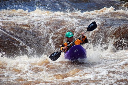
Adrian Tregoning on Hand Stands Up at a high level. Photo by Rowan Walpole.
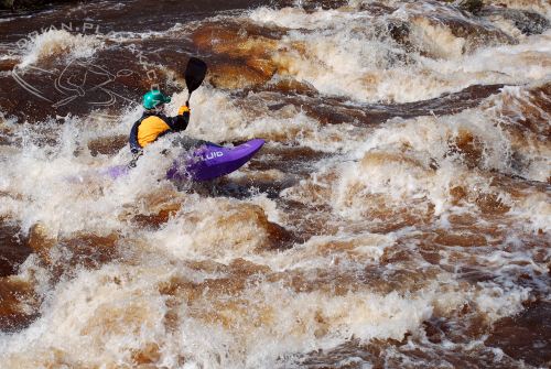
Adrian Tregoning near the end of Bubble and Squeak at a high level. Photo by Rowan Walpole.
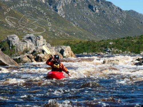
Braam Rademeyer on Bubble and Squeak at a much lower level. Photo by Adrian Tregoning.
Just downstream there are a few twisty channels to negotiate and at low levels things can get interesting if you choose the wrong one. Watch out for getting strained... There are a few areas like this elsewhere on the river too, keep a sharp eye on beginners.
Next up is Itchy and Scratchy. Itchy comes first and is very simple and straight forward. Scratchy is a little more challenging and there are several lines to choose from, depending once again on water level too. Within two hundred metres of this is the so called Waterfall rapid. It has a chute on river left which follows with a wave train. Try to remain upright as there are some shallow rocks. Everything river right of the chute is a ledge about a metre high. This can cause a nasty pourover that can, and will, beat you if you get it wrong at the right level. Exercise caution and use common sense. Scout from the right side. At very high levels it would be better to scout from the left should you feel too nervous or just run without scouting, as most people do.
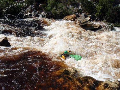
Adrian Tregoning running the pourover line of Waterfall at a medium level. Photo by Rowan Walpole.
Below the waterfall are some small rapids and then a pool ending in a weir. This is the top part of the final rapid, Judgement Day. Run the weir second from the right at most levels, far right if the river is high or portage totally if in doubt. It can also be run far left but it is quite shallow with some strainers just downstream so be sharp. Immediately below this is a rocky little rapid, a right bend and then another narrower weir which forms an excellent play hole at certain levels. It is deep enough to loop and cartwheel in and has eddy service. Just make sure you have a fast roll. A few metres down is the main part of Judgement Day. When the water is medium to low the top part is almost a gentle slide, ending in a narrow hole which is easy to avoid and this too is good for playing in. The water swiftly moves a little left and down towards the final section known as The Gates. There is a large rock in the main flow with a hole directly upstream of it. This causes a lot of carnage and is always a good spot to get photos. Hug the rock to the left or run far left if you’re particularly skittish on the day. At high levels, go right over the big rock.
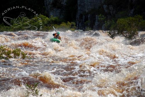
Adrian Tregoning running Judgement Day at flood level. Photo by Braam Rademeyer.
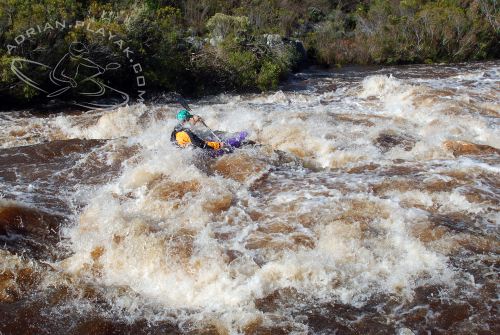
Adrian Tregoning going over the big rock that normally forms The Gates at the end of Judgement Day. Photo by Rowan Walpole.
Hike up on river left below the bridge. There is another rapid directly after the bridge with a hole that works according the river level and the tides. The ocean is only a couple hundred metres away and this hole is influenced by the tides unfortunately. It is not bad for playing although angled so not suited to inexperienced play boaters and mostly it flushes very quickly. Do not jump from the bridge into the water, ever. Several people have been hurt here and I believe one has been killed. There are rocks just under the surface and connecting with them will be bad.
How to get there
From Cape Town, take the N2 out towards Somerset West. Once just out of Somerset West (just past the Shell garage), turn right towards Gordon’s Bay. Turn left at the t-junction and get onto the R44. This road will twist and wind through one of the most beautiful and spectacular areas in South Africa. Keep going straight, past Rooiels, Pringle Bay and then once out of Betty’s Bay, you will cross the Palmiet River 4 km out of Betty’s Bay. This is the take out and the rapid immediately upstream of the bridge is Judgement Day. Leave your car at the parking lot on the river left hand side. Take care not to leave valuables as there have been problems in the past. We haven’t had any problems but I’ve heard of one vehicle being stolen there when a group paddled the full section.
To get to the put in, drive back on the R44, crossing the river again and turn right at the first gravel road. There is a sign saying Kogelberg Nature Reserve. Drive up the road and pay at the boom gate. The entrance fee at the moment is R25 and you’re supposed to be a member of the Cape White Water Club but they have never asked to see my card. From there, drive another 150m and leave your cars there. Walk out for 1.3km on the single track path to get to the river. DO NOT walk through the bush as fynbos is very susceptible to trampling – stick on the paths.
More info
The Palmiet River starts its life high up in the hills just south of Franschhoek. From what I can see on a 1:250 000 map, there are two small rivers which flow into the Nuweberg Dam from the west and I guess the Palmiet could be one of them. That would then be where the source is. North-East-North of Grabouw. Just downstream of this is the next dam, the Eikenhof Dam, then it flows into the north eastern corner of the Kogelberg Dam. From here onwards, the Palmiet begins its journey down south to the sea where it spills into the Atlantic Ocean only a few stone’s throw west of Kleinmond – a distance of about 73km from source to sea.
The Palmiet River basin in the Hottentots Holland Mountains is where a joint venture between Eskom (local power company) and DWAF (Department of Water Affairs and Forestry) was set up. There is a canal and pipeline between Rockview and the Steenbras Dam. Then there is also a system between the upper reservoir, Rockview Dam and the Kogelberg Dam. The Rockview Dam is not on the course of the Palmiet River and sits west of it. The power station is obviously at the Rockview Dam and electricity is supplied according to demand, Monday to Friday. Only some of the water is pumped back from the Kogelberg Dam on a weekly basis. On weekends though, the Rockview Dam fills up with the help of some monster pumps which pump at a phenomenal rate of 126 m^3/s over a period of about 40 hours, which is enough to fill Rockview to capacity again. Not bad! But a shame that us kayakers cannot gain any benefit from such a huge flow. Perhaps they could have created a great play wave where that water enters the upper dam. There is another dam just downstream of the Kogelberg Dam and this is called the Arieskraal Dam.
Rockview does not have much of a catchment and that is why there is a canal and pipeline running from the Steenbras Dam. So if they need to top it up, then they can get water from the Steenbras Scheme. Clever stuff this. What is even more impressive is that the Palmiet Pumped Storage Scheme is largely situated within the Kogelberg Nature Reserve. This world renowned conservation area boasts top quality fynbos and it is good to know that it is being preserved and that strict measures were taken during the construction of all these phases to keep everything as it should be. The Kogelberg Biosphere Reserve was also the first reserve in South Africa to be given biosphere status by Eskom in 1998. This initiative was aimed to integrate conservation of biodiversity and the sustainable utilisation of natural resources. Sustainable - now there's a word you hear a lot these days! To quote directly from Eskom, "The Kogelberg Nature Reserve, in the heart of the Cape Fynbos Plant Kingdom, is part of the Kogelberg Biosphere Reserve, which comprises the entire coastal area from Gordon's Bay to the Bot River vlei to Grabouw and the Groenland Mountain - approximately 92 000 ha."
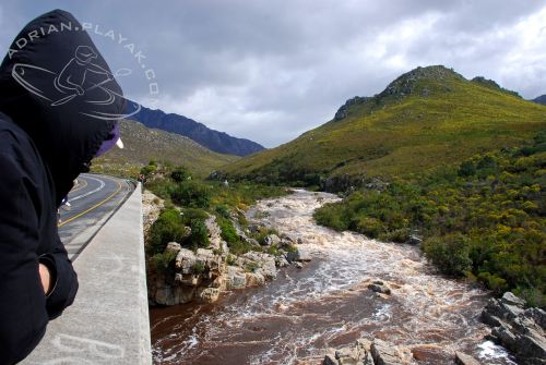
Judgement Day Rapid as seen from the bridge at a flood level. Photo by Adrian Tregoning.
We are truly privileged to be able to kayak in such a pristine place. If you haven’t paddled in the Western Cape, then make a plan. It’s definitely quite different from other areas in South Africa. Another interesting fact – about 58 % of the Palmiet’s catchment is natural, roughly 41 % under agriculture and the roughly 1 or 2 % left is either degraded shrubland or urban – mainly residential or industrial. Still, we drink the water straight from the river! I’ve never been sick and have got a very sensitive stomach. This is not the norm as most of South Africa’s rivers are heavily silted and mostly not suitable for human consumption without some form of treatment.
The Krom River comes in as a tributary from Groenland Berge (Greenland Mountains – direct translation from Afrikaans) just to the west of a peak known as Mount Lebanon at an altitude of 1201m. From these south facing slopes are also a few small rivers which ultimately join the Palmiet. There are also a few other small streams which add to the volume but I will not mention them here.
There is a much longer section to paddle but as I have not yet done it I cannot mention it in detail in this spot description. The put in requires permission from the land owner and a time needs to be arranged so that a gate can be opened. The take out is exactly the same as the short section. There is a serious waterfall type rapid about 6m high on the full section which has only been once, so far. The scenery is world class with good rapids too, although I’m told it is only worthwhile to paddle when the river is quite full as the flats can be quite a slog.
Locals
The river is mostly pretty quiet. Every now and then there will be another group on the river but as with all rivers in South Africa there is no such thing as crowds or localism. An adventure company, Gravity, can often be seen on this section.
Websites
http://www.capenature.org.za/reserves.htm?reserve=Koge lberg+Nature+Reserve#reserve_tabs
http://www.cwwc.co.za/
http://adrian.playak.com/
Info source
For Playak,
Adrian Tregoning, +27 82 656 0252
Nearest weather station (°C): |


